Poster Print > Arts > Artists > J > Thomas Jefferys
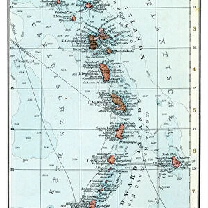
Poster Print : Geography Atlas: representation of the island of Antigua in the Caribbean. Map taken from "The west indian atlas or general description of west indies" by Thomas Jefferys, geographer of the Prince of Wales, 1774. Biblioteca Jose Marti, Havana, Cuba


![]()
Poster Prints from Fine Art Finder
Geography Atlas: representation of the island of Antigua in the Caribbean. Map taken from "The west indian atlas or general description of west indies" by Thomas Jefferys, geographer of the Prince of Wales, 1774. Biblioteca Jose Marti, Havana, Cuba
VEN5030006 Geography Atlas: representation of the island of Antigua in the Caribbean. Map taken from "The west indian atlas or general description of west indies" by Thomas Jefferys, geographer of the Prince of Wales, 1774. Biblioteca Jose Marti, Havana, Cuba.; (add.info.: Geography Atlas: representation of the island of Antigua in the Caribbean. Map taken from "The west indian atlas or general description of west indies" by Thomas Jefferys, geographer of the Prince of Wales, 1774. Biblioteca Jose Marti, Havana, Cuba.); © Marage Photos
Media ID 38478608
© © Marage Photos / Bridgeman Images
Amerique Centrale Amerique Du Nord Caraïbes Caribbean Caribbean Island Carte Geographique Central America Etats Unis Geographie Stockravenna 18eme Siecle Geographical Map
18x24 inch Poster Print
Explore the beauty and history of Antigua with our stunning Poster Print, featuring a vintage map from 'The West Indian Atlas' (1774) by Thomas Jefferys. This exquisite reproduction is perfect for anyone who loves geography, travel, or simply admiring the Caribbean's rich cultural heritage. A unique addition to any room!
Poster prints are budget friendly enlarged prints in standard poster paper sizes. Printed on 150 gsm Matte Paper for a natural feel and supplied rolled in a tube. Great for framing and should last many years. To clean wipe with a microfiber, non-abrasive cloth or napkin. Our Archival Quality Photo Prints and Fine Art Paper Prints are printed on higher quality paper and the choice of which largely depends on your budget.
Poster prints are budget friendly enlarged prints in standard poster paper sizes (A0, A1, A2, A3 etc). Whilst poster paper is sometimes thinner and less durable than our other paper types, they are still ok for framing and should last many years. Our Archival Quality Photo Prints and Fine Art Paper Prints are printed on higher quality paper and the choice of which largely depends on your budget.
Estimated Product Size is 61.6cm x 46.3cm (24.3" x 18.2")
These are individually made so all sizes are approximate
Artwork printed orientated as per the preview above, with landscape (horizontal) orientation to match the source image.
FEATURES IN THESE COLLECTIONS
> Fine Art Finder
> Artists
> Pasquier (workshop of) Grenier
> Arts
> Artists
> J
> Thomas Jefferys
> Arts
> Artists
> N
> Thomas North
> Europe
> United Kingdom
> Wales
> Maps
> Europe
> United Kingdom
> Wales
> Posters
> Europe
> United Kingdom
> Wales
> Related Images
> Maps and Charts
> Early Maps
> Maps and Charts
> Related Images
> Maps and Charts
> Wales
> North America
> Antigua and Barbuda
> Maps
EDITORS COMMENTS
This stunning print from the Geography Atlas showcases the intricate representation of the island of Antigua in the Caribbean, taken from "The West Indian Atlas or General Description of West Indies" by Thomas Jefferys in 1774. The map, housed in Biblioteca Jose Marti in Havana, Cuba, offers a glimpse into the detailed cartography of the time.
Thomas Jefferys, known as the geographer of the Prince of Wales, meticulously crafted this map to provide an accurate depiction of Antigua and its surrounding areas. The fine details and intricate lines on this engraving highlight Jefferys' expertise and dedication to his craft.
As we gaze upon this piece of history, we are transported back to the 18th century when exploration and discovery were at their peak. The map not only serves as a geographical tool but also as a window into the past, offering insights into how people navigated and understood their world centuries ago.
This print is not just a visual representation but a testament to human curiosity and ingenuity. It reminds us of our connection to the land and sea, urging us to explore further and uncover more mysteries that lie beyond our shores.
MADE IN THE USA
Safe Shipping with 30 Day Money Back Guarantee
FREE PERSONALISATION*
We are proud to offer a range of customisation features including Personalised Captions, Color Filters and Picture Zoom Tools
SECURE PAYMENTS
We happily accept a wide range of payment options so you can pay for the things you need in the way that is most convenient for you
* Options may vary by product and licensing agreement. Zoomed Pictures can be adjusted in the Cart.