Poster Print > Arts > Artists > O > Abraham Ortelius
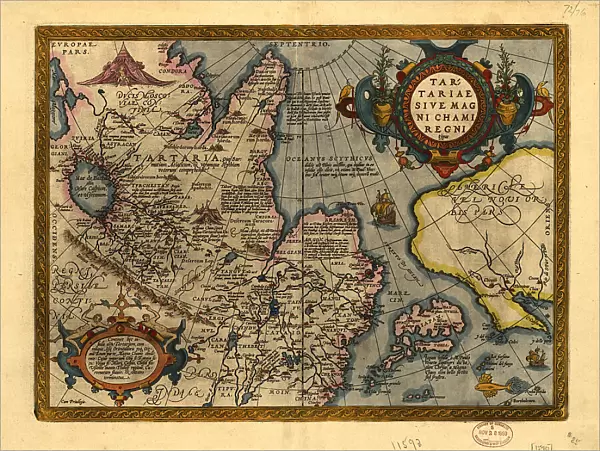
Poster Print : Tartariae sive Magni Chami Regni ty¨pus, 1603. Creators: Abraham Ortelius, Jan Baptist Vrients


![]()
Poster Prints from Heritage Images
Tartariae sive Magni Chami Regni ty¨pus, 1603. Creators: Abraham Ortelius, Jan Baptist Vrients
Tartariae sive Magni Chami Regni ty¨pus, 1603. Covers northern Asia. Relief shown pictorially. From Abraham Ortelius's atlas: Theatrvm Orbis Terrarvm, 1603 ed. Hand col. Includes text, notes, and col. ill. Text on verso
Heritage Images features heritage image collections
Media ID 35129487
© Heritage Art/Heritage Images
1600s Abraham Ortelius Atlas Cartographic Cartography Central Asia Flanders Belgium Europe Latin Map Making Mapmaking Tartary Hand Tinted Meeting Of Frontiers Ortelius Abraham Pictorial Map
18x24 inch Poster Print
Discover the historical allure of the past with our Media Storehouse range of Poster Prints featuring the iconic map "Tartariae sive Magni Chami Regni ty¨pus," created by the renowned cartographers Abraham Ortelius and Jan Baptist Vrients in 1603. This captivating map, taken from Ortelius's seminal work "Theatrvm Orbis Terrarvm," offers a vivid pictorial representation of northern Asia during the early modern era. Each print is meticulously hand-colored, bringing the intricate details and rich history of this map to life. Transport yourself back in time and adorn your walls with this stunning piece of cartographic history.
Poster prints are budget friendly enlarged prints in standard poster paper sizes. Printed on 150 gsm Matte Paper for a natural feel and supplied rolled in a tube. Great for framing and should last many years. To clean wipe with a microfiber, non-abrasive cloth or napkin. Our Archival Quality Photo Prints and Fine Art Paper Prints are printed on higher quality paper and the choice of which largely depends on your budget.
Poster prints are budget friendly enlarged prints in standard poster paper sizes (A0, A1, A2, A3 etc). Whilst poster paper is sometimes thinner and less durable than our other paper types, they are still ok for framing and should last many years. Our Archival Quality Photo Prints and Fine Art Paper Prints are printed on higher quality paper and the choice of which largely depends on your budget.
Estimated Product Size is 61.6cm x 46.3cm (24.3" x 18.2")
These are individually made so all sizes are approximate
Artwork printed orientated as per the preview above, with landscape (horizontal) orientation to match the source image.
FEATURES IN THESE COLLECTIONS
> Arts
> Art Movements
> Renaissance Art
> Arts
> Artists
> O
> Abraham Ortelius
> Europe
> Belgium
> Related Images
> Historic
> Renaissance art
> Northern Renaissance art
> Renaissance art
> Historic
> Renaissance art
> Northern Renaissance art
> Maps and Charts
> Abraham Ortelius
> Maps and Charts
> Early Maps
EDITORS COMMENTS
This print is a rare example of early modern cartographic art, depicting Tartariae sive Magni Chami Regni typus, or the Type of Tartary, also known as Great Cham, from Abraham Ortelius and Jan Baptist Vrients' seminal atlas, Theatrum Orbis Terrarvm, published in 1603. The map covers the vast expanse of northern Asia, with intricate pictorial relief illustrating the geographical features of the region. Ortelius, a renowned Flemish cartographer from the 17th century, and Vrients, his engraver, collaborated on this masterpiece, which was hand-colored to enhance its visual appeal. The map is a testament to the advances in cartography during the Renaissance, as well as the fascination Europeans held for the mysterious lands of Central Asia. The map includes detailed text, notes, and color illustrations, providing valuable insights into the geographical knowledge of the time. The text on the verso offers additional information about the regions depicted, further enriching the map's historical significance. The Library of Congress in Washington D.C. is fortunate to house this precious piece of heritage art, which not only showcases the meeting of frontiers between European and Asian geographical knowledge but also highlights the beauty and artistry of early modern cartography. This map is a must-see for anyone interested in the history of geography, cartography, or the cultural exchange between Europe and Asia during the 17th century.
MADE IN THE USA
Safe Shipping with 30 Day Money Back Guarantee
FREE PERSONALISATION*
We are proud to offer a range of customisation features including Personalised Captions, Color Filters and Picture Zoom Tools
SECURE PAYMENTS
We happily accept a wide range of payment options so you can pay for the things you need in the way that is most convenient for you
* Options may vary by product and licensing agreement. Zoomed Pictures can be adjusted in the Cart.