Home > North America > Martinique > Maps
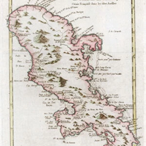
Geography map: representation of the island of Martinique in the small Antilles, made by Dutch cartographer Gerard van Keulen (1678-1726) 1709-1713. Biblioteca Angelica, Rome
 1709-1713. Biblioteca Angelica, Rome")
![]()
Wall Art and Photo Gifts from Fine Art Finder
Geography map: representation of the island of Martinique in the small Antilles, made by Dutch cartographer Gerard van Keulen (1678-1726) 1709-1713. Biblioteca Angelica, Rome
VEN5030213 Geography map: representation of the island of Martinique in the small Antilles, made by Dutch cartographer Gerard van Keulen (1678-1726) 1709-1713. Biblioteca Angelica, Rome; (add.info.: Geography map: representation of the island of Martinique in the small Antilles, made by Dutch cartographer Gerard van Keulen (1678-1726) 1709-1713. Biblioteca Angelica, Rome); © Marage Photos
Media ID 38350246
© © Marage Photos / Bridgeman Images
Amerique Centrale Amerique Du Nord Caraïbes Caribbean Caribbean Island Carte Geographique Central America Dom Tom Etats Unis Geographie Martinican Martinique Stockravenna 18eme Siecle Geographical Map
FEATURES IN THESE COLLECTIONS
> Fine Art Finder
> Artists
> Francois Xavier Fabre
> Maps and Charts
> Early Maps
> North America
> Martinique
> Maps
> North America
> Martinique
> Related Images
> North America
> United States of America
> Maps
> Popular Themes
> North Island
EDITORS COMMENTS
This stunning print of a geography map represents the island of Martinique in the small Antilles, meticulously created by Dutch cartographer Gerard van Keulen between 1709-1713. The intricate details and accuracy of this map showcase the skill and expertise of van Keulen, who was known for his precise cartography during the early 18th century.
Displayed in the Biblioteca Angelica in Rome, this historic piece provides a glimpse into the geographical knowledge and exploration of that time period. The map not only serves as a navigational tool but also as a work of art with its beautifully engraved illustrations and ornate borders.
Martinique, located in the Caribbean region, is depicted with precision on this map, showcasing its topography and geographic features. This representation offers valuable insights into the layout and characteristics of the island during that era.
As we admire this print today, we are transported back to a time when cartographers like van Keulen played a crucial role in mapping out uncharted territories and expanding our understanding of the world. It stands as a testament to human curiosity and ingenuity in exploring new horizons.
MADE IN THE USA
Safe Shipping with 30 Day Money Back Guarantee
FREE PERSONALISATION*
We are proud to offer a range of customisation features including Personalised Captions, Color Filters and Picture Zoom Tools
SECURE PAYMENTS
We happily accept a wide range of payment options so you can pay for the things you need in the way that is most convenient for you
* Options may vary by product and licensing agreement. Zoomed Pictures can be adjusted in the Cart.