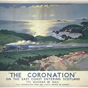
Home > North America > Cuba > Cuba Heritage Sites > Old Havana and its Fortification System
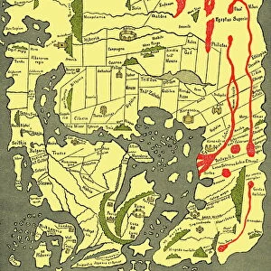
Geography: representation of the island of Hispaniola with the east coast of the island of Cuba in the Caribbean Sea. Map taken from an Atlas of American Cotes by Pieter Vander AA based on the description of the New World at the time of its

![]()
Wall Art and Photo Gifts from Fine Art Finder
Geography: representation of the island of Hispaniola with the east coast of the island of Cuba in the Caribbean Sea. Map taken from an Atlas of American Cotes by Pieter Vander AA based on the description of the New World at the time of its
VEN5031183 Geography: representation of the island of Hispaniola with the east coast of the island of Cuba in the Caribbean Sea. Map taken from an Atlas of American Cotes by Pieter Vander AA based on the description of the New World at the time of its discovery by Christopher Columbus, 1728. Biblioteca Jose Marti, Havana, Cuba.; (add.info.: Geography: representation of the island of Hispaniola with the east coast of the island of Cuba in the Caribbean Sea. Map taken from an Atlas of American Cotes by Pieter Vander AA based on the description of the New World at the time of its discovery by Christopher Columbus, 1728. Biblioteca Jose Marti, Havana, Cuba.); © Marage Photos
Media ID 38425758
© © Marage Photos / Bridgeman Images
Amerique Centrale Amerique Du Nord Caraïbes Caribbean Caribbean Island Carte Geographique Central America Etats Unis Geographie Stockravenna 18eme Siecle Geographical Map
FEATURES IN THESE COLLECTIONS
> Asia
> East Timor
> Maps
> Asia
> East Timor
> Related Images
> Fine Art Finder
> Artists
> Pasquier (workshop of) Grenier
> Maps and Charts
> Early Maps
> Maps and Charts
> World
> North America
> Cuba
> Cuba Heritage Sites
> Old Havana and its Fortification System
> North America
> Cuba
> Havana
> North America
> Cuba
> Maps
> North America
> Cuba
> Related Images
> North America
> United States of America
> Maps
EDITORS COMMENTS
This stunning print captures a historical representation of the island of Hispaniola and the east coast of Cuba in the Caribbean Sea. The map, taken from an Atlas of American Coasts by Pieter Vander AA in 1728, offers a glimpse into the description of the New World at the time of its discovery by Christopher Columbus.
Displayed at Biblioteca Jose Marti in Havana, Cuba, this piece showcases the intricate details and geographical features that were known to explorers and cartographers during the 18th century. The map provides a window into early colonial history, highlighting key locations and landmarks that shaped the development of these regions.
As we gaze upon this image, we are transported back in time to an era when exploration and discovery were paramount. The vibrant colors and intricate lines on this map serve as a reminder of how far our understanding of geography has come since then.
This print is not just a visual representation but also a historical artifact that tells a story of adventure, curiosity, and innovation. It serves as a testament to human ingenuity and perseverance in uncovering new lands and expanding our knowledge of the world around us.
MADE IN THE USA
Safe Shipping with 30 Day Money Back Guarantee
FREE PERSONALISATION*
We are proud to offer a range of customisation features including Personalised Captions, Color Filters and Picture Zoom Tools
SECURE PAYMENTS
We happily accept a wide range of payment options so you can pay for the things you need in the way that is most convenient for you
* Options may vary by product and licensing agreement. Zoomed Pictures can be adjusted in the Cart.