
Caribbean Island Collection (page 2)

Discover the captivating charm of a Caribbean island, where history and beauty intertwine

Background imageCaribbean Island Collection: Common smoothhand, Mustelus mustelus, Vulnerable 1, angler fish, Lophius piscatorius 2, burrfish

Common smoothhand, Mustelus mustelus, Vulnerable 1, angler fish, Lophius piscatorius 2, burrfish
FLO4652692 Common smoothhand, Mustelus mustelus, Vulnerable 1, angler fish, Lophius piscatorius 2, burrfish, Chilomycterus schoepfi 3, and bill of a sawfish, Pristis pectinata

Background imageCaribbean Island Collection: Engraving depicting a Carolina anole, an arboreal lizard found primarily in the south-eastern

Engraving depicting a Carolina anole, an arboreal lizard found primarily in the south-eastern United States
5308950 Engraving depicting a Carolina anole, an arboreal lizard found primarily in the south-eastern United States and some Caribbean islands

Background imageCaribbean Island Collection: English West Indies - French Antilles - Le Francois, Habitation Clement, Domaine de l'Mahogany

English West Indies - French Antilles - Le Francois, Habitation Clement, Domaine de l'Mahogany
JEB4949605 English West Indies - French Antilles - Le Francois, Habitation Clement, Domaine de l'Mahogany. Homere Clement (1858-1923), Doctor of Medicine in 1878, Mayor of the Francois 1885-1923

Background imageCaribbean Island Collection: French West Indies - French Antilles - Fonds Saint Jacques, Sugar Housing du Pere Labat (1663-1736)

French West Indies - French Antilles - Fonds Saint Jacques, Sugar Housing du Pere Labat (1663-1736)
JEB4950121 French West Indies - French Antilles - Fonds Saint Jacques, Sugar Housing du Pere Labat (1663-1736). Cane mill - Martinique

Background imageCaribbean Island Collection: French West Indies - French Antilles - Fonds Saint Jacques, Sugar Housing du Pere Labat (1663-1736)

French West Indies - French Antilles - Fonds Saint Jacques, Sugar Housing du Pere Labat (1663-1736) - Martinique
JEB4950068 French West Indies - French Antilles - Fonds Saint Jacques, Sugar Housing du Pere Labat (1663-1736) - Martinique

Background imageCaribbean Island Collection: Trois Ilets, Domaine de la Pagerie, Bust of Josephine de Beauharnais - Martinique

Trois Ilets, Domaine de la Pagerie, Bust of Josephine de Beauharnais - Martinique, island of the French Antilles
JEB4949222 Trois Ilets, Domaine de la Pagerie, Bust of Josephine de Beauharnais - Martinique, island of the French Antilles; (add.info.: Trois Ilets, Domaine de la Pagerie)

Background imageCaribbean Island Collection: French West Indies - French Antilles - La Trinite, Le chateau Dubuc was built in 1721

French West Indies - French Antilles - La Trinite, Le chateau Dubuc was built in 1721, by Louis du Buc du Galion
JEB4949096 French West Indies - French Antilles - La Trinite, Le chateau Dubuc was built in 1721, by Louis du Buc du Galion, grandson of Pierre du Buc, Sieur de La Caravelle et du Marigot

Background imageCaribbean Island Collection: French West Indies - French Antilles - Fort de France, cathedrale Saint Louis inspired by

French West Indies - French Antilles - Fort de France, cathedrale Saint Louis inspired by the Eiffel style
JEB4948748 French West Indies - French Antilles - Fort de France, cathedrale Saint Louis inspired by the Eiffel style. Its construction began in 1893 under the direction of Pierre Henri Picq

Background imageCaribbean Island Collection: A canoe being used by Island Caribs, 1850

A canoe being used by Island Caribs, 1850
3330590 A canoe being used by Island Caribs, 1850; (add.info.: Engraving depicting a canoe being used by Island Caribs, an indigenous peoples of the Lesser Antilles in the Caribbean)

Background imageCaribbean Island Collection: Sir Walter Raleigh's Conquest of the City of St Joseph in the Isle of Trinidad

Sir Walter Raleigh's Conquest of the City of St Joseph in the Isle of Trinidad
3329529 Sir Walter Raleigh's Conquest of the City of St Joseph in the Isle of Trinidad; (add.info.: Engraving depicting Sir Walter Raleigh's Conquest of the City of St Joseph in the Isle of)

Background imageCaribbean Island Collection: Map of the island of Hispaniola (Santo Domingo or Haiti), Caribbean Sea

Map of the island of Hispaniola (Santo Domingo or Haiti), Caribbean Sea, circa 1870 - Lithograph 19th century
NWI4866878 Map of the island of Hispaniola (Santo Domingo or Haiti), Caribbean Sea, circa 1870 - Lithograph 19th century (Map of Hispaniola, including Haiti and Santo Domingo, 1870s)

Background imageCaribbean Island Collection: Geography map: representation of the southern island of Cuba and the island of Hispaniola

Geography map: representation of the southern island of Cuba and the island of Hispaniola and the small Caribbean
VEN5030180 Geography map: representation of the southern island of Cuba and the island of Hispaniola and the small Caribbean, made by the Dutch cartographer Gerard van Keulen (1678-1726) 1709-1713

Background imageCaribbean Island Collection: Geography Atlas: representation of the island of Hispaniola (which includes Santo Domingo and Haiti)

Geography Atlas: representation of the island of Hispaniola (which includes Santo Domingo and Haiti)
VEN5031366 Geography Atlas: representation of the island of Hispaniola (which includes Santo Domingo and Haiti) in the Caribbean archipelago. Map by the Knight Lapie, 1819

Background imageCaribbean Island Collection: Geography Atlas: representation of the island of Santo Domingo

Geography Atlas: representation of the island of Santo Domingo, the Bahamas of Puerto Rico to the West Indies
VEN5031345 Geography Atlas: representation of the island of Santo Domingo, the Bahamas of Puerto Rico to the West Indies. Map from an atlas of 1867

Background imageCaribbean Island Collection: Geography: map showing the Gulf of Mexico and the Caribbean Sea islands (Caribbean)

Geography: map showing the Gulf of Mexico and the Caribbean Sea islands (Caribbean)
VEN5031257 Geography: map showing the Gulf of Mexico and the Caribbean Sea islands (Caribbean). Plate taken from an Atlas by Philippe Buache (1700-1773) 1780

Background imageCaribbean Island Collection: Geography Atlas: description of the Caribbean Sea, Caribbean Sea (Cuba, Jamaica, Hispaniola)

Geography Atlas: description of the Caribbean Sea, Caribbean Sea (Cuba, Jamaica, Hispaniola, Jamaica)
VEN5031247 Geography Atlas: description of the Caribbean Sea, Caribbean Sea (Cuba, Jamaica, Hispaniola, Jamaica), the Bahamas Islands and the Lesser Antilles with map

Background imageCaribbean Island Collection: Geography: map showing Central America (Mexico, Honduras, Yucatan)

Geography: map showing Central America (Mexico, Honduras, Yucatan) and the Caribbean Sea Islands (Antilles)
VEN5031211 Geography: map showing Central America (Mexico, Honduras, Yucatan) and the Caribbean Sea Islands (Antilles). Plate from a British Atlas of 1737

Background imageCaribbean Island Collection: Geography: map of the islands of Central America (Antilles), the Detroit of Panama

Geography: map of the islands of Central America (Antilles), the Detroit of Panama and representation of Mexico City
VEN5031188 Geography: map of the islands of Central America (Antilles), the Detroit of Panama and representation of Mexico City

Background imageCaribbean Island Collection: Geography: representation of the island of Hispaniola with the east coast of the island of Cuba in

Geography: representation of the island of Hispaniola with the east coast of the island of Cuba in the Caribbean Sea
VEN5031183 Geography: representation of the island of Hispaniola with the east coast of the island of Cuba in the Caribbean Sea

Background imageCaribbean Island Collection: Geography Atlas: representation of the region of the Caribbean Sea, the Greater Antilles (Cuba)

Geography Atlas: representation of the region of the Caribbean Sea, the Greater Antilles (Cuba, Jamaica)
VEN5030081 Geography Atlas: representation of the region of the Caribbean Sea, the Greater Antilles (Cuba, Jamaica, Hispaniola) and the small Antilles with colours indicating membership to France

Background imageCaribbean Island Collection: Geography Atlas: representation of North America and the Caribbean Sea region, Caribbean (Cuba)

Geography Atlas: representation of North America and the Caribbean Sea region, Caribbean (Cuba, Jamaica, Hispaniola)
VEN5030064 Geography Atlas: representation of North America and the Caribbean Sea region, Caribbean (Cuba, Jamaica, Hispaniola, Jamaica). Map from an Atlas by Adrien Hubert Brue (1786-1832), 1821

Background imageCaribbean Island Collection: Geography Atlas: representation of the Caribbean archipelago (Cuba, Hispaniola, Puerto Rico)

Geography Atlas: representation of the Caribbean archipelago (Cuba, Hispaniola, Puerto Rico), the Bahamas Islands
VEN5030034 Geography Atlas: representation of the Caribbean archipelago (Cuba, Hispaniola, Puerto Rico), the Bahamas Islands. Map from a Spanish Atlas of 1825

Background imageCaribbean Island Collection: Geography Atlas: representation of the island of Hispaniola (which includes Santo Domingo and Haiti)

Geography Atlas: representation of the island of Hispaniola (which includes Santo Domingo and Haiti)
VEN5030030 Geography Atlas: representation of the island of Hispaniola (which includes Santo Domingo and Haiti) in the Caribbean archipelago

Background imageCaribbean Island Collection: Geography Atlas: representation of the island of Saint Lucia (Antilles)

Geography Atlas: representation of the island of Saint Lucia (Antilles). Map taken from "The west indian atlas or
VEN5030018 Geography Atlas: representation of the island of Saint Lucia (Antilles). Map taken from "The west indian atlas or general description of west indies" by Thomas Jefferys

Background imageCaribbean Island Collection: Geography Atlas: representation of the island of Jamaica (Antilles)

Geography Atlas: representation of the island of Jamaica (Antilles). Map taken from "The west indian atlas or
VEN5030010 Geography Atlas: representation of the island of Jamaica (Antilles). Map taken from "The west indian atlas or general description of west indies" by Thomas Jefferys

Background imageCaribbean Island Collection: Harvesting of tree's resin called chibou, cachibou or gomartis or gum or mastic

Harvesting of tree's resin called chibou, cachibou or gomartis or gum or mastic on the gumbo-limbo, copperwood
ELD4919328 Harvesting of tree's resin called chibou, cachibou or gomartis or gum or mastic on the gumbo-limbo, copperwood, chaca

Background imageCaribbean Island Collection: Strategic Map of Our War with Spain

Strategic Map of Our War with Spain
2902891 Strategic Map of Our War with Spain; (add.info.: Strategic Map of Our War with Spain, 1898.); Buyenlarge Archive/UIG

Background imageCaribbean Island Collection: Point Royal, Jamaica New Granada, 18th century (engraving)

Point Royal, Jamaica New Granada, 18th century (engraving)
2902884 Point Royal, Jamaica New Granada, 18th century (engraving); Buyenlarge Archive/UIG

Background imageCaribbean Island Collection: The Evening Post map of the West Indies, 1898

The Evening Post map of the West Indies, 1898
2902870 The Evening Post map of the West Indies, 1898; (add.info.: The Evening Post map of the West Indies, 1898.); Buyenlarge Archive/UIG

Background imageCaribbean Island Collection: Map of Guadeloupe, c.1900 (engraving)

Map of Guadeloupe, c.1900 (engraving)
533480 Map of Guadeloupe, c.1900 (engraving); (add.info.: Map of Guadeloupe, circa 1902, from the 10th edition of Encyclopaedia Britannica.); Encyclopaedia Britannica/UIG

Background imageCaribbean Island Collection: Map of Dominica, c.1900 (engraving)

Map of Dominica, c.1900 (engraving)
533477 Map of Dominica, c.1900 (engraving); (add.info.: Map of Dominica, circa 1902, from the 10th edition of Encyclopaedia Britannica.); Encyclopaedia Britannica/UIG

Background imageCaribbean Island Collection: The turtle, c.1910 (print)

The turtle, c.1910 (print)
7293390 The turtle, c.1910 (print); (add.info.: Food and beverage. The turtle as food. Imagery in: Histoire anecdotique de l'alimentation, France, ca 1910.); Photo: © Archives Charmet

Background imageCaribbean Island Collection: Crantzia tigrina (Heintzia tigrina). Handcoloured lithograph from Louis van Houtte

Crantzia tigrina (Heintzia tigrina). Handcoloured lithograph from Louis van Houtte
FLO4629832 Crantzia tigrina (Heintzia tigrina). Handcoloured lithograph from Louis van Houtte and Charles Lemaire's Flowers of the Gardens and Hothouses of Europe

Background imageCaribbean Island Collection: Geography: Map of Saint Kitts and Nevis Island in the West Indies

Geography: Map of Saint Kitts and Nevis Island in the West Indies. Map from an Atlas by Bryan Edwards (1743-1800)
VEN5031320 Geography: Map of Saint Kitts and Nevis Island in the West Indies. Map from an Atlas by Bryan Edwards (1743-1800) from 1791

Background imageCaribbean Island Collection: Geography: map showing the Gulf of Mexico, the Caribbean Islands, Central America (Mexico)

Geography: map showing the Gulf of Mexico, the Caribbean Islands, Central America (Mexico, Yucatan, Salvador, Honduras)
VEN5031242 Geography: map showing the Gulf of Mexico, the Caribbean Islands, Central America (Mexico, Yucatan, Salvador, Honduras, Nicaragua, Costarica) and northern South America (Venezuela)

Background imageCaribbean Island Collection: Geography map: representation of the islands of the Greater Antilles (Cuba, Hispaniola)

Geography map: representation of the islands of the Greater Antilles (Cuba, Hispaniola)
VEN5030434 Geography map: representation of the islands of the Greater Antilles (Cuba, Hispaniola, Jamaica and Puerto Rico) and the Lesser Antilles in the Caribbean Sea

Background imageCaribbean Island Collection: Geography map: representation of the main British islands of the Caribbean Sea (Antigua, Barbados)

Geography map: representation of the main British islands of the Caribbean Sea (Antigua, Barbados, Jamaican, Bermuda)
VEN5030269 Geography map: representation of the main British islands of the Caribbean Sea (Antigua, Barbados, Jamaican, Bermuda, St. Christopher Island or St)

Background imageCaribbean Island Collection: Geography map: representation of the island of Martinique in the small Antilles

Geography map: representation of the island of Martinique in the small Antilles
VEN5030213 Geography map: representation of the island of Martinique in the small Antilles, made by Dutch cartographer Gerard van Keulen (1678-1726) 1709-1713

Background imageCaribbean Island Collection: Geography map: representation of part of the archipelago of the small Antilles

Geography map: representation of part of the archipelago of the small Antilles (island of Saint Lucia, Martinique)
VEN5030211 Geography map: representation of part of the archipelago of the small Antilles (island of Saint Lucia, Martinique, Dominica, Ile des Saintes, Guadeloupe, Montserrat, Antigua, Barbuda)

Background imageCaribbean Island Collection: Geography map: representation of the Orenoque River in Venezuela, the Gulf of Paria

Geography map: representation of the Orenoque River in Venezuela, the Gulf of Paria, the islands of Tobago
VEN5030093 Geography map: representation of the Orenoque River in Venezuela, the Gulf of Paria, the islands of Tobago, Trinidad (Trinidad)

Background imageCaribbean Island Collection: Geography Atlas: representation of North America and the Caribbean Sea region, Caribbean (Cuba)

Geography Atlas: representation of North America and the Caribbean Sea region, Caribbean (Cuba, Jamaica, Hispaniola)
VEN5030056 Geography Atlas: representation of North America and the Caribbean Sea region, Caribbean (Cuba, Jamaica, Hispaniola, Jamaica). Map from an Atlas of 1785

Background imageCaribbean Island Collection: Geography Atlas: representation of South America and the Caribbean Sea region, Caribbean (Cuba)

Geography Atlas: representation of South America and the Caribbean Sea region, Caribbean (Cuba, Jamaica, Hispaniola)
VEN5030051 Geography Atlas: representation of South America and the Caribbean Sea region, Caribbean (Cuba, Jamaica, Hispaniola)

Background imageCaribbean Island Collection: Geography Atlas: representation of the Bahamas islands, northern Hispaniola (Santo Domingo)

Geography Atlas: representation of the Bahamas islands, northern Hispaniola (Santo Domingo)
VEN5029631 Geography Atlas: representation of the Bahamas islands, northern Hispaniola (Santo Domingo) and the Leewind Passage between Cuba and Hispaniola in the West Indies

Background imageCaribbean Island Collection: Geography Atlas: representation of the Bequia or Becouya Islands in the North of the Grenadines in

Geography Atlas: representation of the Bequia or Becouya Islands in the North of the Grenadines in the Caribbean Sea
VEN5029628 Geography Atlas: representation of the Bequia or Becouya Islands in the North of the Grenadines in the Caribbean Sea

Background imageCaribbean Island Collection: Geography Atlas: representation of the island of Martinique in the West Indies

Geography Atlas: representation of the island of Martinique in the West Indies
VEN5029597 Geography Atlas: representation of the island of Martinique in the West Indies. Map taken from "The west indian atlas or general description of west indies" by Thomas Jefferys

Background imageCaribbean Island Collection: Caribbean cucumber (Cucumis anguria). Lithograph from 'Afbeelding der Artseny-Gewassen' by

Caribbean cucumber (Cucumis anguria). Lithograph from "Afbeelding der Artseny-Gewassen" by Johannes Zorn
FLO4737977 Caribbean cucumber (Cucumis anguria). Lithograph from "Afbeelding der Artseny-Gewassen" by Johannes Zorn (1739-1799), Netherlands, 1796. West Indian gherkin, Cucumis anguria

Background imageCaribbean Island Collection: Woven hammock used by the Island Carib or Kalinago people. Handcoloured copperplate engraving

Woven hammock used by the Island Carib or Kalinago people. Handcoloured copperplate engraving from Giulio
FLO4621561 Woven hammock used by the Island Carib or Kalinago people. Handcoloured copperplate engraving from Giulio Ferrario's Costumes Antique and Modern of All Peoples

Background imageCaribbean Island Collection: Rattan table and sneakers for food and fish made by the Island Carib or Kalinago people, West Indies

Rattan table and sneakers for food and fish made by the Island Carib or Kalinago people, West Indies
FLO4621678 Rattan table and sneakers for food and fish made by the Island Carib or Kalinago people, West Indies. Handcoloured copperplate engraving by Migliavacca from Giulio Ferrario's Costumes


For sale as Licensed Images

Choose your image, Select your licence and Download the media

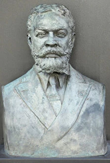
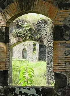
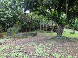
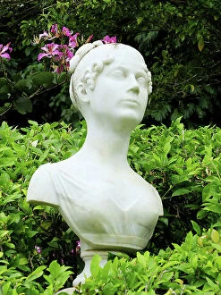
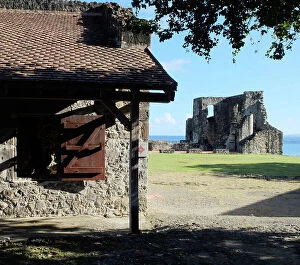
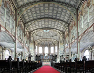
Discover the captivating charm of a Caribbean island, where history and beauty intertwine. 🌴✨ From the vibrant streets of Cuba's historical center in Havana, adorned with the iconic Havana Club painted on bar walls, to the legacy left by Cuban President Tomas Estrada Palma, every corner tells a fascinating story. In Vedado, Havana's neighborhood, stands the magnificent Iglesia de San Juan de Letran, an architectural gem that showcases the rich heritage of this enchanting island. Travel back in time to Ponce, Puerto Rico in the 1890s and witness its timeless allure captured through GATL2A-00033. Nature lovers will be mesmerized by Holguin's breathtaking scenery near Playa Esmeralda (GATL2A-00027), offering a serene escape amidst lush landscapes. Explore Villa Nova plantation house once owned by. . [missing information]. Marvel at Jardines del Rey archipelago in Villa Clara Province as you venture into Cayo Santa Maria – a true paradise on earth. Immerse yourself in history through stunning watercolor depictions of Guiana Indians from c. 1843-50 and Mestee and mulatto girls of Dominica from the same era. These artworks offer glimpses into cultural diversity that has shaped these islands over time. Lastly, pay your respects at Hotel Valentino's Book of Condolence in Cayo Santa Maria as it honors Cuban memories lost but never forgotten. Embark on an unforgettable journey to this Caribbean island where vibrant culture meets natural wonders – an experience that will leave you enchanted forever.