Photographic Print > Europe > Italy > Lazio > Rome
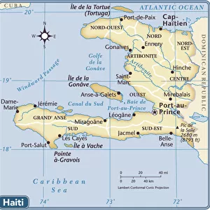
Photographic Print : Geography map: representation of the coasts of Florida, the Bahamas Islands, the island of Cuba and part of the island of Hispaniola (Santo Domingo and Haiti), made by the Dutch cartographer Gerard van Keulen (1678-1726) 1709-1713
, made by the Dutch cartographer Gerard van Keulen (1678-1726) 1709-1713")
![]()
Photo Prints from Fine Art Finder
Geography map: representation of the coasts of Florida, the Bahamas Islands, the island of Cuba and part of the island of Hispaniola (Santo Domingo and Haiti), made by the Dutch cartographer Gerard van Keulen (1678-1726) 1709-1713
VEN5030120 Geography map: representation of the coasts of Florida, the Bahamas Islands, the island of Cuba and part of the island of Hispaniola (Santo Domingo and Haiti), made by the Dutch cartographer Gerard van Keulen (1678-1726) 1709-1713. Biblioteca Angelica, Rome; (add.info.: Geography map: representation of the coasts of Florida, the Bahamas Islands, the island of Cuba and part of the island of Hispaniola (Santo Domingo and Haiti), made by the Dutch cartographer Gerard van Keulen (1678-1726) 1709-1713. Biblioteca Angelica, Rome); © Marage Photos
Media ID 38167630
© © Marage Photos / Bridgeman Images
Amerique Centrale Amerique Du Nord Caraïbes Caribbean Caribbean Island Carte Geographique Central America Cuba Cuba Cubain Cubaine Cubains Cubaines Cuban Dominium Etats Unis Geographie Haiti Saint Domingue Stockravenna 18eme Siecle Geographical Map
12"x8" Photo Print
Explore the rich history of the Caribbean with this stunning vintage map featuring Florida, the Bahamas Islands, Cuba, and Hispaniola. Perfect for adding a touch of old-world charm to any space.
Photo prints are produced on Kodak professional photo paper resulting in timeless and breath-taking prints which are also ideal for framing. The colors produced are rich and vivid, with accurate blacks and pristine whites, resulting in prints that are truly timeless and magnificent. Whether you're looking to display your prints in your home, office, or gallery, our range of photographic prints are sure to impress. Dimensions refers to the size of the paper in inches.
Our Photo Prints are in a large range of sizes and are printed on Archival Quality Paper for excellent colour reproduction and longevity. They are ideal for framing (our Framed Prints use these) at a reasonable cost. Alternatives include cheaper Poster Prints and higher quality Fine Art Paper, the choice of which is largely dependant on your budget.
Estimated Product Size is 30.5cm x 20.3cm (12" x 8")
These are individually made so all sizes are approximate
Artwork printed orientated as per the preview above, with landscape (horizontal) orientation to match the source image.
FEATURES IN THESE COLLECTIONS
> Fine Art Finder
> Artists
> Unknown Artist
> Europe
> Italy
> Lazio
> Rome
> Maps and Charts
> Early Maps
> Maps and Charts
> Related Images
> North America
> The Bahamas
> Maps
> North America
> The Bahamas
> Related Images
> North America
> Cuba
> Maps
> North America
> Cuba
> Related Images
> North America
> Haiti
> Maps
> North America
> Haiti
> Related Images
EDITORS COMMENTS
This stunning geography map, created by the talented Dutch cartographer Gerard van Keulen in the early 18th century, provides a detailed representation of the coasts of Florida, the Bahamas Islands, Cuba, and part of Hispaniola (Santo Domingo and Haiti). The intricate engravings showcase the beauty and complexity of these Caribbean regions during this time period.
Van Keulen's meticulous attention to detail is evident in every line and curve on this map, capturing not only the geographical features but also the cultural significance of each area. From the lush landscapes of Florida to the vibrant coastlines of Cuba and Hispaniola, this map offers a glimpse into a world that was both familiar and exotic to those who studied it centuries ago.
As we gaze upon this historical artifact now preserved in Biblioteca Angelica in Rome, we are reminded of the importance of cartography in understanding our world. Each stroke of Van Keulen's pen tells a story - one that speaks volumes about exploration, discovery, and interconnectedness among nations.
This print serves as a timeless reminder of how geography shapes our perceptions and interactions with different lands and peoples. It invites us to explore beyond borders and appreciate the diversity that makes our planet so rich and fascinating.
MADE IN THE USA
Safe Shipping with 30 Day Money Back Guarantee
FREE PERSONALISATION*
We are proud to offer a range of customisation features including Personalised Captions, Color Filters and Picture Zoom Tools
SECURE PAYMENTS
We happily accept a wide range of payment options so you can pay for the things you need in the way that is most convenient for you
* Options may vary by product and licensing agreement. Zoomed Pictures can be adjusted in the Cart.