Home > Europe > Italy > Emilia-Romagna > Ravenna
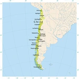
Geography map: representation of Tierra de fuego and Patagonia (Argentina, Chile), made by Dutch cartographer Gerard van Keulen (1678-1726) 1709-1713. Biblioteca Angelica, Rome
, made by Dutch cartographer Gerard van Keulen (1678-1726) 1709-1713. Biblioteca Angelica, Rome")
![]()
Wall Art and Photo Gifts from Fine Art Finder
Geography map: representation of Tierra de fuego and Patagonia (Argentina, Chile), made by Dutch cartographer Gerard van Keulen (1678-1726) 1709-1713. Biblioteca Angelica, Rome
VEN5030138 Geography map: representation of Tierra de fuego and Patagonia (Argentina, Chile), made by Dutch cartographer Gerard van Keulen (1678-1726) 1709-1713. Biblioteca Angelica, Rome; (add.info.: Geography map: representation of Tierra de fuego and Patagonia (Argentina, Chile), made by Dutch cartographer Gerard van Keulen (1678-1726) 1709-1713. Biblioteca Angelica, Rome); Photo © Marco Ravenna
Media ID 38274422
© © Marco Ravenna / Bridgeman Images
Amerique Du Nord Amerique Du Sud Argentina Argentina Argentinean Argentine Argentine Argentin Argentins Argentines Argentinian Argentinians Carte Geographique Chile Chilean Chili Chilian Chilians Etats Unis Geographie Latin America Latinamerica Republic Of Chile Southamerica Stockravenna 18eme Siecle Geographical Map Latine America
FEATURES IN THESE COLLECTIONS
> Europe
> Italy
> Emilia-Romagna
> Ravenna
> Europe
> Italy
> Lazio
> Rome
> Fine Art Finder
> Artists
> Marcantonio Bassetti
> Maps and Charts
> Early Maps
> Maps and Charts
> Related Images
> North America
> United States of America
> Maps
> South America
> Argentina
> Maps
> South America
> Argentina
> Related Images
> South America
> Chile
> Maps
> South America
> Chile
> Related Images
EDITORS COMMENTS
This stunning print captures a historic geography map of Tierra de Fuego and Patagonia, created by the talented Dutch cartographer Gerard van Keulen in the early 18th century. The intricate details and accuracy of this map showcase Van Keulen's skill and dedication to his craft.
Tierra de Fuego and Patagonia are regions known for their rugged beauty and unique landscapes, making them popular subjects for cartographers throughout history. This particular representation provides a glimpse into how these areas were perceived over three centuries ago.
The map is housed in the Biblioteca Angelica in Rome, a fitting location for such a valuable piece of cartographic history. The library's collection includes many rare and important works, making it a treasure trove for researchers and enthusiasts alike.
Through the lens of photographer Marco Ravenna, we are able to appreciate not only the artistry of Van Keulen's map but also the preservation efforts that have allowed it to survive through the years. This print serves as a reminder of the importance of historical maps in understanding our world's past and present geography.
MADE IN THE USA
Safe Shipping with 30 Day Money Back Guarantee
FREE PERSONALISATION*
We are proud to offer a range of customisation features including Personalised Captions, Color Filters and Picture Zoom Tools
SECURE PAYMENTS
We happily accept a wide range of payment options so you can pay for the things you need in the way that is most convenient for you
* Options may vary by product and licensing agreement. Zoomed Pictures can be adjusted in the Cart.