Home > Africa > South Africa > Maps
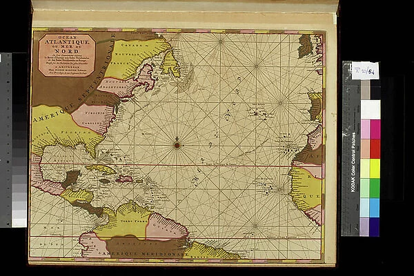
Geography map: representation of the Atlantic Ocean (or North Sea) with the coasts of the Americas (South and United States), the Caribbean Sea and the Caribbean, the coasts of West Africa and Spain
![]()

Wall Art and Photo Gifts from Fine Art Finder
Geography map: representation of the Atlantic Ocean (or North Sea) with the coasts of the Americas (South and United States), the Caribbean Sea and the Caribbean, the coasts of West Africa and Spain
VEN5030386 Geography map: representation of the Atlantic Ocean (or North Sea) with the coasts of the Americas (South and United States), the Caribbean Sea and the Caribbean, the coasts of West Africa and Spain. Plate taken from an atlas by Pierre Mortier (1661-1711), beginning of the 18th century. Biblioteca Angelica, Rome; (add.info.: Geography map: representation of the Atlantic Ocean (or North Sea) with the coasts of the Americas (South and United States), the Caribbean Sea and the Caribbean, the coasts of West Africa and Spain. Plate taken from an atlas by Pierre Mortier (1661-1711), beginning of the 18th century. Biblioteca Angelica, Rome); © Marage Photos
Media ID 38484908
© © Marage Photos / Bridgeman Images
Amerique Centrale Amerique Du Nord Amerique Du Sud Atlantic Ocean Caraïbes Caribbean Caribbean Island Carte Geographique Central America Etats Unis Geographie Latin America Latinamerica Ocean Atlantique Southamerica Stockravenna 18eme Siecle Geographical Map Latine America
FEATURES IN THESE COLLECTIONS
> Africa
> South Africa
> Maps
> Africa
> South Africa
> Related Images
> Fine Art Finder
> Artists
> Pasquier (workshop of) Grenier
> Maps and Charts
> Early Maps
> Maps and Charts
> Spain
> North America
> United States of America
> Maps
> Popular Themes
> North Island
> South America
> Related Images
EDITORS COMMENTS
This stunning print of a geography map from the 18th century showcases the vast expanse of the Atlantic Ocean, also known as the North Sea, with intricate details of the coasts of the Americas including South America and the United States. The map also highlights the Caribbean Sea and islands, as well as the coastlines of West Africa and Spain.
Created by Pierre Mortier in the early 1700s, this plate is a true work of art that captures the essence of exploration and discovery during that time period. The fine engravings and detailed geographical features make this map a valuable historical artifact.
As you study this map closely, you can almost feel yourself being transported back in time to an era when cartographers meticulously charted out unknown territories and navigated treacherous waters. The representation of different continents and countries on this map serves as a reminder of how interconnected our world truly is.
Whether you're a history buff or simply appreciate beautiful artwork, this geography map print is sure to captivate your imagination and spark your curiosity about distant lands across oceans. It's a testament to human ingenuity and perseverance in exploring new horizons.
MADE IN THE USA
Safe Shipping with 30 Day Money Back Guarantee
FREE PERSONALISATION*
We are proud to offer a range of customisation features including Personalised Captions, Color Filters and Picture Zoom Tools
SECURE PAYMENTS
We happily accept a wide range of payment options so you can pay for the things you need in the way that is most convenient for you
* Options may vary by product and licensing agreement. Zoomed Pictures can be adjusted in the Cart.


