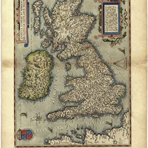
Metal Print > Arts > Artists > O > Abraham Ortelius
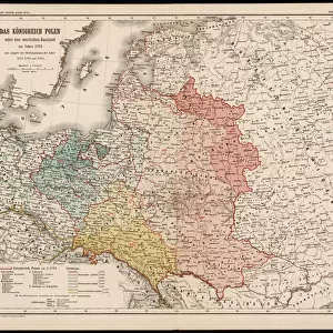
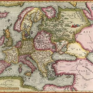
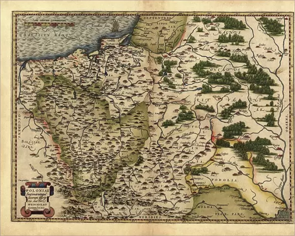
Metal Print : Orteliuss map of Poland, 1570


![]()
Metal Prints from Science Photo Library
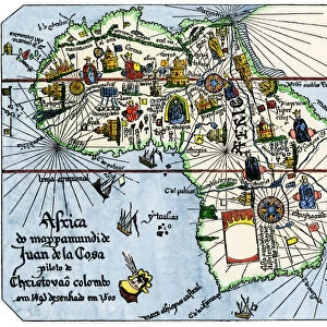
Orteliuss map of Poland, 1570
Orteliuss map of Poland. This map is from the 1570 first edition of Theatrum orbis terrarum ( Theatre of the World ). Drawn by the Flemish mapmaker Abraham Ortelius (1527-1598), and published by Gilles Coppens de Diest in Antwerp, this collection of 53 maps is considered to be the first true modern atlas
Science Photo Library features Science and Medical images including photos and illustrations
Media ID 6297807
© LIBRARY OF CONGRESS, GEOGRAPHY AND MAP DIVISION/SCIENCE PHOTO LIBRARY
1500s 1570 1570 Edition 16th Century Abraham Ortelius Age Of Discovery Antwerp Edition Cartographic Cartography Country Dutch First Edition First Modern Atlas Flemish Gilles Coppens De Diest Latin Latin Edition Nation Orteliuss Poland Polish Text Theatre Of The World Theatrum Orbis Terrarum Writing Kingdom Of Poland
16"x20" (51x41cm) Metal Print
Discover history through art with our Media Storehouse Metal Prints featuring the iconic Ortelius Map of Poland from 1570. This exquisite piece is taken from the first edition of Theatrum orbis terrarum, meticulously crafted by the renowned Flemish cartographer Abraham Ortelius. Bring the rich detail and intriguing history of this 16th-century map into your home or office, as our high-quality metal prints showcase vibrant colors and exceptional clarity. Elevate your space with a touch of historical elegance and geographical curiosity.
Made with durable metal and luxurious printing techniques, our metal photo prints go beyond traditional canvases, adding a cool, modern touch to your space. Wall mount on back. Eco-friendly 100% post-consumer recycled ChromaLuxe aluminum surface. The thickness of the print is 0.045". Featuring a Scratch-resistant surface and Rounded corners. Backing hangers are attached to the back of the print and float the print 1/2-inch off the wall when hung, the choice of hanger may vary depending on size and International orders will come with Float Mount hangers only. Finished with a brilliant white high gloss surface for unsurpassed detail and vibrance. Printed using Dye-Sublimation and for best care we recommend a non-ammonia glass cleaner, water, or isopropyl (rubbing) alcohol to prevent harming the print surface. We recommend using a clean, lint-free cloth to wipe off the print. The ultra-hard surface is scratch-resistant, waterproof and weatherproof. Avoid direct sunlight exposure.
Made with durable metal and luxurious printing techniques, metal prints bring images to life and add a modern touch to any space
Estimated Image Size (if not cropped) is 50.8cm x 40.6cm (20" x 16")
Estimated Product Size is 51.4cm x 41.2cm (20.2" x 16.2")
These are individually made so all sizes are approximate
Artwork printed orientated as per the preview above, with landscape (horizontal) orientation to match the source image.
FEATURES IN THESE COLLECTIONS
> Arts
> Artists
> O
> Abraham Ortelius
> Europe
> Poland
> Related Images
> Maps and Charts
> Abraham Ortelius
> Maps and Charts
> Early Maps
> Maps and Charts
> Related Images
> Maps and Charts
> World
EDITORS COMMENTS
This print showcases Orteliuss map of Poland, a remarkable piece of cartographic artistry from the 16th century. Created by the talented Flemish mapmaker Abraham Ortelius and published in Antwerp by Gilles Coppens de Diest, this particular edition is hailed as the first true modern atlas. The collection comprises 53 meticulously crafted maps, with this one specifically highlighting the Kingdom of Poland. The intricate details on this historical illustration transport us back to a time when exploration and discovery were at their peak during the Age of Discovery. Every stroke and Latin text on this map tells a story of geographical significance, offering insights into Polands rich history and its place within Europe. As we delve into this visual masterpiece, we are reminded that it was created during an era where accurate cartography held immense value for nations seeking to expand their influence across borders. This print serves as a testament to both artistic skill and scientific precision. Whether you have an affinity for European history or simply appreciate fine craftsmanship, Orteliuss map of Poland provides a window into the past that is both educational and visually stunning. It stands as a timeless reminder of how far our understanding of geography has come since those early days of exploration.
MADE IN THE USA
Safe Shipping with 30 Day Money Back Guarantee
FREE PERSONALISATION*
We are proud to offer a range of customisation features including Personalised Captions, Color Filters and Picture Zoom Tools
SECURE PAYMENTS
We happily accept a wide range of payment options so you can pay for the things you need in the way that is most convenient for you
* Options may vary by product and licensing agreement. Zoomed Pictures can be adjusted in the Cart.