Premium Framed Print > Arts > Artists > O > Abraham Ortelius
Premium Framed Print : Orteliuss map of Poland, 1570


![]()
Framed Photos from Science Photo Library
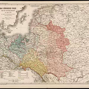
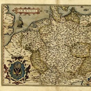
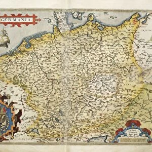
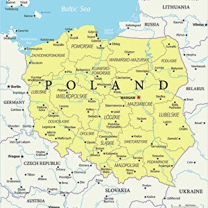
Orteliuss map of Poland, 1570
Orteliuss map of Poland. This map is from the 1570 first edition of Theatrum orbis terrarum ( Theatre of the World ). Drawn by the Flemish mapmaker Abraham Ortelius (1527-1598), and published by Gilles Coppens de Diest in Antwerp, this collection of 53 maps is considered to be the first true modern atlas
Science Photo Library features Science and Medical images including photos and illustrations
Media ID 6297807
© LIBRARY OF CONGRESS, GEOGRAPHY AND MAP DIVISION/SCIENCE PHOTO LIBRARY
1500s 1570 1570 Edition 16th Century Abraham Ortelius Age Of Discovery Antwerp Edition Cartographic Cartography Country Dutch First Edition First Modern Atlas Flemish Gilles Coppens De Diest Latin Latin Edition Nation Orteliuss Poland Polish Text Theatre Of The World Theatrum Orbis Terrarum Writing Kingdom Of Poland
14"x16" Premium Frame
Contemporary style Premium Wooden Frame with 8"x10" Print. Complete with 2" White Mat and 1.25" thick MDF frame. Printed on 260 gsm premium paper. Glazed with shatter proof UV coated acrylic glass. Backing is paper covered backing with rubber bumpers. Supplied ready to hang with a pre-installed sawtooth/wire hanger. Care Instructions: Spot clean with a damp cloth. Securely packaged in a clear plastic bag and envelope in a reinforced cardboard shipper
FSC Real Wood Frame and Double Mounted with White Conservation Mountboard - Professionally Made and Ready to Hang
Estimated Image Size (if not cropped) is 25.4cm x 20.3cm (10" x 8")
Estimated Product Size is 40.6cm x 35.6cm (16" x 14")
These are individually made so all sizes are approximate
Artwork printed orientated as per the preview above, with landscape (horizontal) orientation to match the source image.
FEATURES IN THESE COLLECTIONS
> Arts
> Artists
> O
> Abraham Ortelius
> Europe
> Poland
> Related Images
> Maps and Charts
> Abraham Ortelius
> Maps and Charts
> Early Maps
> Maps and Charts
> Related Images
> Maps and Charts
> World
EDITORS COMMENTS
This print showcases Orteliuss map of Poland, a remarkable piece of cartographic artistry from the 16th century. Created by the talented Flemish mapmaker Abraham Ortelius and published in Antwerp by Gilles Coppens de Diest, this particular edition is hailed as the first true modern atlas. The collection comprises 53 meticulously crafted maps, with this one specifically highlighting the Kingdom of Poland. The intricate details on this historical illustration transport us back to a time when exploration and discovery were at their peak during the Age of Discovery. Every stroke and Latin text on this map tells a story of geographical significance, offering insights into Polands rich history and its place within Europe. As we delve into this visual masterpiece, we are reminded that it was created during an era where accurate cartography held immense value for nations seeking to expand their influence across borders. This print serves as a testament to both artistic skill and scientific precision. Whether you have an affinity for European history or simply appreciate fine craftsmanship, Orteliuss map of Poland provides a window into the past that is both educational and visually stunning. It stands as a timeless reminder of how far our understanding of geography has come since those early days of exploration.
MADE IN THE USA
Safe Shipping with 30 Day Money Back Guarantee
FREE PERSONALISATION*
We are proud to offer a range of customisation features including Personalised Captions, Color Filters and Picture Zoom Tools
SECURE PAYMENTS
We happily accept a wide range of payment options so you can pay for the things you need in the way that is most convenient for you
* Options may vary by product and licensing agreement. Zoomed Pictures can be adjusted in the Cart.